GEOGRAPHY DEPARTMENT WEATHER LINKS
OKLAHOMA STATE UNIVERSITY
This site is for use by the students and faculty of Oklahoma State University for educational purposes only. We cannot guarantee the status of any of the links.
![]()
WEATHER WATCHES AND WARNINGS FROM NATIONAL WEATHER SERVICE
![]()
WEATHER RADARS
The following NEXRAD sites cover Oklahoma: Vance Air Force Base (KVNC), Frederick (KFDR), Oklahoma City (KTLX), Tulsa (KINX), Ft. Smith (KSRX), and Amarillo (KAMA).
Oklahoma City Courtesy National Weather Service
Tulsa Courtesy National Weather Service
Southwestern Oklahoma Courtesy National Weather Service
East Central and Southeastern Oklahoma (Ft. Smith, AR) Courtesy National Weather Service
Oklahoma Panhandle (Amarillo) Courtesy National Weather Service
Northern Oklahoma (Vance Air Force Base) Courtesy National Weather Service
Oklahoma and surrounding radars National Weather Service radars through Oklahoma Mesonet software*
*This site allows interactive use. Download the free Wxscope browser plug-in from the Mesonet here Oklahoma Mesonet // Data
National Radar and all individual radars National Weather Service Radars courtesy of RAP at UCAR
Intellicast National Weather Service Radar courtesy of Intellicast
![]()
NOAA WEATHER RADIO BROADCASTS
Western Oklahoma: Controlled by the Norman Weather Service Forecast Office
Eastern Oklahoma: Controlled by the Tulsa Weather Service Forecast Office
Panhandle counties, Oklahoma: NOAA weather radio does not reach to these counties
McCurtain County, Oklahoma: controlled by the Shreveport Weather Service Forecast Office
![]()
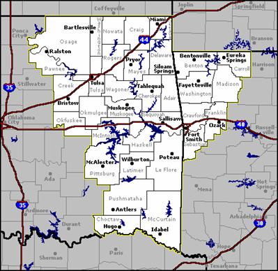
NATIONAL WEATHER SERVICE FORECAST OFFICE HOME PAGES
Oklahoma is covered by three National Weather Service offices. Their areas of responsibility are shown on the maps.
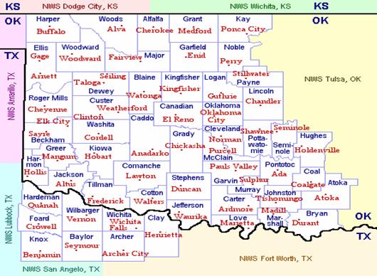
TULSA WEATHER SERVICE FORECAST OFFICE NORMAN WEATHER SERVICE FORECAST OFFICE
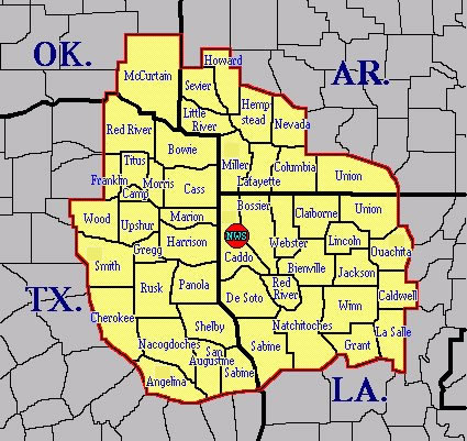
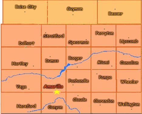
SHREVEPORT WEATHER SERVICE FORECAST OFFICE AMARILLO WEATHER SERVICE FORECAST OFFICE
(Includes McCurtain County, Oklahoma) (The 3 northernmost counties are the Oklahoma panhandle)
National Weather Service Southern Regional Headquarters
![]()
OKLAHOMA MESONET
The Oklahoma Mesonet is a joint project between the University of Oklahoma and Oklahoma State University. Data are available online each five minutes along with recent archives. By downloading the free Wxscope browser plug-in, you can take advantage of interactive map and animated features.
Meteograms: Time series of data at individual Mesonet sites
Mesonet Products and Information
Mesonet Outreach and Education
![]()
OKLAHOMA SATELLITE IMAGES
Current Visible, Infrared, and Water Vapor (single images and animations) Courtesy RAP at UCAR*
Current Visible, Infrared, and Water Vapor (single images and animations) Courtesy National Weather Service*
*Oklahoma is featured by clicking on the ICT (Wichita) scene center)
![]()
AIR QUALITY
Air Now U.S. Government Cross-Agency Site
![]()
ASTRONOMICAL CALCULATIONS
Sun and Moon Calculations Courtesy U.S. Naval Observatory
Current Day/Night Map of Earth Courtesy of John Walker
World Clock Courtesy of Timeanddate.com
![]()
SPACE ENVIRONMENT
![]()
OKLAHOMA WEATHER CAMS
Oklahoma City Courtesy KWTV
Tulsa Courtesy KTUL
Stillwater Courtesy Oklahoma State University
Stillwater Courtesy Eskimo Joe's (inferred weather from the dress of the clientele)
![]()
ARCHIVED DATA
Oklahoma Climatological Survey
World Meteorological Organization
Daily Weather Maps Courtesy NCEP NOAA
EXCELLENT WEATHER SITES
Aviation Digital Data Service for pilots
IWIN: Portal to all NWS weather links
Weather Analysis Page Courtesy College of DuPage
Electronic Weather Wall Courtesy Penn State University