
Go Directly to the US Places Visited Map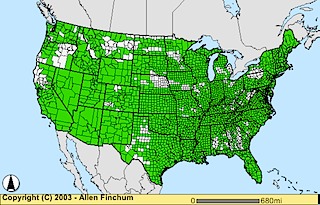
NOTES: I have created this ArcIMS project/website as a learning experience for myself and a few students, and therefore it will be undergoing constant changes and improvements. As I visit new counties and other places I will add them to the various layers provided in the existing maps, and I plan to further customize the User Interface in the future. When you zoom in from the nationwide view, an alternate set of geographic data for US Counties and State boundaries will automatically be loaded, and a layer for US Highways becomes available (although not automatically loaded). This geographic data is from the National Transportation Atlas Databases (NTAD) which are very detailed and quite large, so the creation and download of the maps to your browser can be a bit slow. If you are on a T1 or similar connection the maps can take a few seconds to download, and on a standard 28.8 modem it can take almost a full minute. Please be patient. Thank you.
DESCRIPTION: These maps show counties (and independent cities) in the Continental US I have visited in the past 44 years or so (OK, I was born in 1958, so a few of these places I may not really remember very well, but 98% or so I have visited since 1970). The initial view of the map shows counties visited or not ("on or off"). The initial color scheme shows counties I have visited through 14 August 2006 as Green and Non-Visited Counties as White.
The initial map display/color scheme can be modified to show county names, as well as a visit sequence of when and with whom I visited a place. The color scheme for the Period display depicts the following "eras" and persons with whom I visited a place:
0-White: Never Visited - (401 as of 14 August 2006)
1-Lite Blue: Visited with my father/parents only, sometime between
1958 and 1980 (1,265).
2-Turquise: Visited by myself, or with persons not otherwise listed in
this pattern (137).
3-Lite Green: Visited with OSU Colleagues since 1996 (154).
4-Tan: Visited with my wife Tanya since 1980 (182).
5-Lite Brown: Visited with my son Curtis since 2000 (82).
6-Brown: Visited with both Tanya and Curtis since 1990 (890).
As of 2 December 2009 I have made at least cursory visits to 2,710 of the 3,111 such political entities in the Continental US (87.1%). I have also visited the primary counties (5) and major cities in Hawaii, as well as several of the boroughs/census zones, cities, and major points of interest in Alaska, including Anchorage, Fairbanks, Juneau, and Denali/Mt McKinley National Park.
The categories are hierarchical, in that if a county is in group 1 or 2, and then I visit with it Tanya and/or Curtis, it becomes a 4, 5, or 6.
Also, through 14 August 2006 I have completed all of the county visits for the following 24 States in the Continental US (1171 Total Counties):
- Arizona (15)
- Arkansas (75)
- Connecticut (8)
- Delaware (3)
- Florida (67)
- Indiana (92)
- Kansas (105)
- Louisiana (64)
- Maine (16)
- Maryland (24)
- Massachusetts (14)
- Mississippi (82)
- Nevada (16)
- New Hampshire (10)
- New Jersey (21)
- New Mexico (32)
- North Carolina (100)
- Oklahoma (77)
- Rhode Island (5)
- Tennessee (95)
- Utah (29)
- Vermont (14)
- Virginia (136 - Counties and Independent Cities)
- Wisconsin (71)
For Wyoming I need only 1 more county, and I need only 2 to complete Idaho.
Also shown on this map are Major League Baseball, NFL, NBA, NHL, college football and basketball facilities in which I have attended a game, as well as college campuses I have visited. I have also included commercial passenger airports I have flown into or out of, either as a terminal point or as a connecting stopover. Each of these layers can be turned off or on as the viewer desires. It is also my plan to add more pictures to the site from my personal slide collection or pictures provided by friends and colleagues I travel with in the near future. I hope you enjoy the mapsite.